

Previous |
Colin's Munros |
Next |
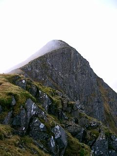
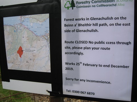
WARNING: Sgorr Dhearg Path closed during 2019
(see photo above).
There is tree felling in the forestry of Gleann a' Chaolais (Glenachulish)
making the normal path to Sgorr Dhearg impassable.
No alternative route is provided.
However, on descent, from the forest corner at NN04965615 to the path
where it crosses the track at NN04755756,
you might try contouring NW round the upper edge of the forest for 800m to
about NN04475663, heading down through the forest for 400m to the loop
in the forest track at NN04515685, going left along the track for 800m
to the T-junction at NN04425696, then turning right along the track
to re-join the path at NN04755756.
This should be easier to follow on ascent. The forest is not too dense.
Another alternative is Route 3 which starts in Ballachulish
and goes along the track to the south of Beinn a' Bheithir, avoiding Glenachulish entirely.
Route 1 (14/06/19): This is the normal circular route and usually a better choice than either route 2 or route 3. There is a good track or well-constructed path through all the forestry. A minor issue is the scree on the final ascent up to the col west of Sgorr Dhonuill. This may make a clockwise direction preferable, but the counter-clockwise route described next puts the prevailing wind behind on the ridge.
| 1 | Park at P in South Ballachulish | 45 | 0 | 0.00 miles | NN04705891 |
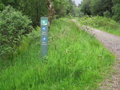
| 2 | Track S to signpost at path split | 60 | 105 | 0.45 miles | NN04705821 |
| 3 | Follow right “Sgorr Dhonuill” track SW to head of valley | 295 | 250 | 1.65 miles | NN03755677 |
| 4 | Path SSW to ridge (Some scree for final 120m of ascent) | 775 | 730 | 2.55 miles | NN02955553 |
| 5 | Ridge E to M Sgorr Dhonuill | 1001 | 955 | 3.30 miles | NN04065553 |
| 6 | E to bealach | 755 | 3.75 miles | NN04795546 | |
| 7 | ENE to M Sgorr Dhearg | 1024 | 1225 | 4.45 miles | NN05695584 |
| 8 | (Optional detour to Munro top:) E to col | 900 | NN06155591 | ||
| 9 | NE to T Sgorr Bhan | 947 | 1270 | 4.80 miles | NN06275604 |
| 10 | Return SW to col | 900 | NN06155591 | ||
| 11 | W to M Sgorr Dhearg | 1024 | 1392 | 5.25 miles | NN05695584 |
| 12 | Return WSW to bealach | 755 | 5.85 miles | NN04795546 | |
| 13 | Follow path N to forest corner | 525 | 6.30 miles | NN04965616 | |
| 14 | Path NNE along forest edge to forest entry. (Note the short ascent just before entering the forest.) |
500 | 6.55 miles | NN05145650 | |
| 15 | Return by path/track N to car park. | 45 | 1410 | 8.50 miles | NN04705891 |
Route 2 (09/06/07): This is the normal route and usually a better choice than route 3. There is a well-constructed path up to the edge of the forestry.
| 1 | Park at P in South Ballachulish NN046589 | 45 | 0 | 0.0 miles |
| 2 | Tracks & path S to col NN048555 | 755 | 710 | 2.5 miles |
| 3 | W over bump to M Sgorr Dhonuill | 1001 | 955 | 3.0 miles |
| 4 | Return E to col | 755 | 3.5 miles | |
| 5 | ENE to M Sgorr Dhearg | 1024 | 1225 | 4.15 miles |
| 6 | E to col | 900 | ||
| 7 | NE to T Sgorr Bhan | 947 | 1270 | 4.6 miles |
| 8 | Return SW to col | 900 | ||
| 9 | W to M Sgorr Dhearg | 1024 | 1395 | 5.05 miles |
| 10 | Return WSW to col | 755 | 5.7 miles | |
| 11 | Return by path/track N to car park. | 45 | 1412 | 8.2 miles |
Route 3 (26/11/04):
I traded the usual route, route 2, for a boring start on an easy
track which I could do in semi-darkness and an enjoyable descent from Sgorr Ban at the end.
There are good paths along the ridge and along the valley, but no connecting path up to col on this route.
It is probably better to do this route in reverse, ascending by the sharp NE ridge of
Sgorr Ban to S of Allt a'Choire Riabhaich (as recommended in SMC Munro book.)
Weather: Overcast but clearing; cloud at 1000m; showery; 20 mins rain from 1010.
| 0640 | Park at P in Ballachulish NN084585 (first right once off A82). |
5 | 0 | 0.0 miles |
| Take B road S to bridge over river, cross footbridge and take C road S passed school to quarry NN081574. |
60 | 55 | 0.75 miles | |
| 0820 | Ascend excellent track S/SW/W to dense Forestry Commission trees NN057546. |
275 | 270 | 3.4 miles |
| Ascend N to corner of forestry (350m) and set compass direct to bealach. |
350 | 345 | ||
| 0920 | NW to Bealach NN047555 | 755 | 750 | 4.2 miles |
| 0950 | W over bump to M Sgorr Dhonuill NN040555 | 1001 | 1005 | 4.7 miles |
| 1010 | Return E to bealach NN047555 | 755 | 5.2 miles | |
| 1040 | E/ENE to M Sgorr Dhearg NN056558 (trig post) | 1024 | 1275 | |
| 1050 | E down to col | 901 | ||
| 1055 | NE to T Sgorr Bhan NN062560 | 947 | 1320 | 6.3 miles |
| Unwisely descended scree gully into Coire Riabhaich instead of taking the NE ridge to its south. |
||||
| NE to track at quarry | 60 | 7.8 miles | ||
| 1225 | N to P in Ballachulish. | 5 | 1320m | 8.6 miles |
| Previous | Top | Next |