Previous |
Colin's Munros |
Next |
Rating:
Classic Route, deservedly 5 star status.
Access:
There are two convenient parking places. The first is opposite forestry
at NG973138 on the NW-bound side of the A87 at Malagan,
3.9 miles east of the petrol station at Shiel Bridge,
7.8 miles W of Cluanie Inn, 1.75 miles after Eas-nan-Arm bridge over R. Shiel.
The other, unmarked on the 1:25000 map, is about 550m NW of the bridge at Malagan,
at NG967144 on the SE-bound side of the A87.
The latter is the better choice for those omitting Sgurr na Sgine.
Route:
As usual, my route includes all the associated Munro tops.
On west ridge of The Saddle there are of two these, which adds 2.5 miles to the distance
and 340m (3100') to the ascent.
The Munro Sgurr na Sgine is usually included with any ascent of The Saddle.
The shapely Corbett top Faochag (a deleted Munro top) is an excellent finale to the day
and requires almost no extra effort. Underfoot it is certainly the best return route as well.
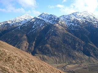
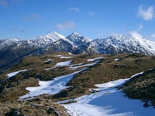
The Forcan ridge is a straight-forward, but slightly exposed, scramble
along a ridge that is literally knife edge at one point: you can sit astride it!
Watch out for the bad step immediately after reaching the summit of Sgurr na Forcan:
a 20m near vertical drop.
It might be better named the “big bad step” because of its height.
This can be the crux of the climb, technically slightly harder than the In Pin,
but it has a superfluity of excellent holds and is not difficult, just exposed.
Moreover, there is an easy descent via a gully by-passing the step on the south side.
The two guys behind me used a rope.
That did not seem necessary to me even in the winter conditions,
but only in retrospect. From its orientation,
the sun keeps the face fairly dry and so it is probably often ice-free in winter.
It is a ridge worthy of comparison with those in Skye, with some tricky exposed moves
on the ascent. If you enjoy this, then you'll do fine in Skye.
In wet conditions, I strongly advise avoiding the bad step by using the by-pass to the south.
The easiest way to bag the summit of Sgurr na Forcan is certainly as an excursion
from the trig point, using the by-pass. This involves essentially no scrambling.
There are plenty of pictures of the bad step to study on the internet.
If you have not done any scrambling before, don't attempt other parts of the Forcan ridge yet.
Gain some easier experience first.
Most of the route from the base of the Forcan ridge to Bealach Coire Mhalagain is rocky,
with numerous little pinnacles on the narrow ridges.
These add considerably to the expected traversal time, especially in wet conditions
when extra care is necessary on the slippery rocks,
and the amount of ascent noted above is an under-estimate because of this.
For those descending to the A87 directly from Bealach Coire Mhalagain, please note that
the path from the summit of the Saddle becomes indistinct on the bealach but
it can be picked up easily lower down at the wall (outlined on the 1:25k map)
which runs approximately horizontally from below the bealach round to the base
of the Forcan ridge at NG9465613072 (GPS).
The path follows the wall, but is very tiresome because of
the big rock scree which it crosses.
Map: Use the OS 1:25000 map. The 1:50000 does not have enough detail.
Note that the OS post is not at the summit.
Conditions 16/3/06: Cold but dry, mostly cloud-free day. 4°C at car.
Light but sharp E wind. Snow above 600m, crampons necessary above 750m.
Conditions 26/9/08: Stiff, cool breeze; overcast; dry.
| 16/3/06 | 26/9/08 | Description | Ht. | Asc. | Dist. | Grid Ref. | Mob. |
| 0855 | 0650 | Parking immediately SE of Malagan Bridge | 40 | 0 | 0.0 miles | NG97301378 | Talkmobile |
| Walk NW along road 350m beyond Malagan Bridge to gate at path end. |
30 | 0.4 miles | NG9465613072 | ||||
| 0955 | 0755 | Ascend formerly excellent stalkers' path (degraded by modern amateurish "repair" work) SW then NW to Bealach na Craoibhe. |
496 | 470 | 1.85 miles | NG95181417 | |
| 1030 | 0830 | Continue S/SW on path up Meallan Odhar to cairn/wall at foot of Forcan ridge |
680 | 650 | 2.6 miles | NG9465613072 | |
| 0845 | Scramble up to top of first section of ridge | 825 | 795 | 2.85 miles | NG94431313 | ||
| 1115 | 0905 | W up ridge to T Sgurr na Forcan | 963 | 955 | 3.1 miles | NG94031305 | |
| W down exposed bad step (20m) or gully on S side to col |
935 | 3.2 miles | NG93911305 | ||||
| W to top | 958 | 975 | 3.25 miles | NG93831304 | |||
| WNW to col | 935 | 3.28 miles | NG93761307 | ||||
| 1145 | 0930 | WNW to true summit M The Saddle | 1010 | 1050 | 3.4 miles | NG93611313 | |
| SW to dip | 995 | miles | NG93551310 | ||||
| 1150 | 0935 | SW to The Saddle (trig pt) | 1010 | 1065 | 3.5 miles | NG93481307 | Orange |
| W/WSW to col | 950 | 3.7 miles | NG93101291 | ||||
| 1225 | 0955 | The Saddle – W Top | 968 | 1075 | 3.95 miles | NG92781282 | No Orange |
| 1005 | W to col | 891 | 4.2 miles | NG92361284 | |||
| 1245 | 1010 | WNW to T Spidean Dhomhuill Bhric | 939 | 1125 | 4.3 miles | NG92221294 | No Orange |
| W to col | 853 | 4.5 miles | NG91951300 | ||||
| 1305 | 1025 | NW/NNW to T Sgurr Leac nan Each | 919 | 1190 | 4.7 miles | NG9177313313 | No Orange |
| Return S/SSE/SE to col | 853 | 4.95 miles | NG91951300 | ||||
| 1325 | 1042 | E to T Spidean Dhomhuill Bhric | 939 | 1275 | 5.1 miles | NG92221294 | No Orange |
| ESE to col | 891 | 5.25 miles | NG92361284 | ||||
| 1350 | 1100 | E to The Saddle – W Top | 968 | 1345 | 5.5 miles | NG92781282 | No Orange |
| ENE to col | 950 | 5.7 miles | NG93101291 | ||||
| 1415 -1425 | 1120 -1125 |
ENE to The Saddle (trig pt) | 1010 | 1405 | 5.95 miles | NG93481307 | Orange |
| 1500 | 1155 | Descend SE ridge and then E across corrie to Lochan Bealach Coire Mhalagain. |
699 | 6.7 miles | NG94401252 | ||
| 1525 | 1215 | (If necessary, return via path by wall to base of Forcan ridge.) Otherwise, path SE to ridge cairn (almost at top) |
880 | 1585 | 6.9 miles | NG94521212 | |
| 1535 | 1220 | Path SW/S to col | 857 | 7.07 miles | NG94441189 | ||
| 1545 -1550 | 1230 | S to T Sgurr na Sgine, NW Top (Not a very worthy Munro top.) |
942 | 1660 | 7.27 miles | NG94381158 | No Orange |
| SE to col | 921 | 7.33 miles | NG94451152 | ||||
| 1600 | 1240 | SE to M Sgurr na Sgine (Orange 5m from summit) |
946 | 1685 | 7.45 miles | NG94581138 | No Orange |
| Return NW to col | 921 | 7.55 miles | NG94451152 | ||||
| 1605 | 1250 | NW to T Sgurr na Sgine, NW Top | 942 | 1705 | 7.62 miles | NG94381158 | No Orange |
| N to col | 857 | 7.82 miles | NG94441189 | ||||
| 1620 | 1305 | N/NNE to top (near cairn for path up) | 880 | 1715 | 7.97 miles | NG94521212 | |
| E to col | 855 | 8.25 miles | NG94931224 | ||||
| 1640 | 1320 | E to Faochag | 909 | 1790 | 8.6 miles | NG95461234 | Orange |
| 1405 | Path NE down ridge towards Allt Mhalagain path: Stile in deer fence |
280 | 9.45 miles | NG96641309 | |||
| 1420 | Gate in deer fence & river ford.
(There is a bridge slightly upstream if necessary) |
55 | 9.83 miles | NG97091351 | |||
| 1755 | 1430 | Track N back to A87 parking layby. | 40 | 1795 | 10.3 miles | NG97301378 | Talkmobile |
| Previous | Top | Next |