Previous |
Colin's Munros |
Next |
Route:
As usual for these pages, this route includes the associated two Munro tops,
which lie out to the west of the two Munros.
They make a very pleasant addition with good views, excellent terrain, and very little extra ascent.
The only disadvantage of this longer route is that the local estate doesn't allow you to walk through
Clashgour farm and directs walkers along the rubbishy track beside the Abhainn Shira (Linne nam Beathach)
between Clashgour and the green corrugated iron hut at Allt Toaig.
Instead, I prefer a diversion to the north of the farm, as in my GPS route.
However, the scenery along the Abhainn Shira is much better than that in the Clashgour woods.
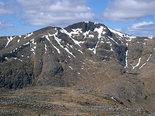
In my opinion the ridge is best walked from E to W because of the steep screes ascending Stob Ghabhar,
but consider doing the route in reverse if there is strong weather from the SW.
My GPS route gives the standard ascent for the screes,
but in poor conditions one alternative to them
might be to take the ridge north of Coirein Lochain via a gully that rises NE
to three tiny lochans at Airse nan Each NN242465.
However, another alternative to those screes which I first used when there was heavy snow on the usual route
is to ascend a gully almost at the east end of Aonach Eagach. I will probably always use it in future.
After the descent from Stob a'Choire Odhair, cross the Allt Toaig on the flat area near the path at NN24474551.
Then ascend diagonally left to the bottom of a convenient buttress around NN24604525.
Ascend the buttress with trivial scrambling to the flat ridge near NN24434514.
From here it is an easy walk on pleasant terrain to the top of the Couloir Buttress (Aonach Eagach).
This diversion off the standard route halves the amount of steep ascent by
transferring half to a gentle grassy ridge and replaces loose terrain with firm.
These two alternatives are outlined in the GPS route
here.
Terrain:
There are excellent roads, tracks and paths almost throughout, as well as
very friendly vegetation on any higher ground where there are no paths.
The only poor stretches are parts of the path along the Linne nam Beathach
(if that alternative is chosen),
and the screes up to Aonach Eagach are tiresome in the usual way.
Overall, this makes for much faster walking than average.
Weather 13/5/06:
Sunny, the odd cloud am, 8°C at car initially, rising to 14°C at car finally.
24/9/10:
Stiff cold wind, 6–8°C at car, 2°C on tops, sunny, tops clear.
Access:
Take minor road to Victoria Bridge from A82 in Bridge of Orchy,
turning right on the far side of the bridge after 100m.
Use sign-posted parking at Victoria Bridge, ½ mile after Inveroran hotel,
before crossing the Abhainn Shira (about 3.5 miles from A82).
| 13/5/06 | 24/9/10 | Description | Ht. | Asc. | Dist. | Grid Ref. |
| 0915 | 0920 | Park at P at Victoria Bridge | 170 | 0 | 0.0 miles | NN27134202 |
| N along road over Victoria bridge | 170 | NN27084218 | ||||
| 0920 | Left at Forest Lodge, 100m beyond bridge, onto track beside Abhainn Shira. |
175 | NN27064228 | |||
| 0935 | 0945 | W along track to Clashgour Hut. | 185 | 15 | 1.35 miles | NN25624247 |
| Turn right (north) along superb track beside Allt Toaig to track end |
350 | 180 | 2.3 miles | NN25214420 | ||
| 1015 | 1025 | Continue N to: Path split at ford of Allt Caolain Dubh |
435 | 265 | 2.8 miles | NN25324467 |
| Excellent path N/NE up ridge | 900 | 730 | NN25574582 | |||
| 1105 -1110 | 1135 -1140 |
Continue to M Stob a'Choire Odhair (Orange) | 945 | 775 | 3.7 miles | NN25734598 |
| WSW down ridge to bend, being careful not to retrace the ascent path – there should be a cliff to the right. |
850 | NN25224584 | ||||
| 1210 -1215 |
W down ridge to bealach | 668 | 4.6 miles | NN24364581 | ||
| 1140 | Continue 100m W to (unclear) path split | 680 | 790 | NN24254576 | ||
| Continue a further 250m to next path split | 720 | 830 | NN24034581 | |||
| Bear WSW to path end on 1:50000 map | 780 | 4.9 miles | NN23754575 | |||
| 1215 | 1315 | Continue obvious steep path S through screes up ridge to top of Couloir Buttress (first top with cairn) |
970 | 1080 | NN23714542 | |
| 1225 | 1322.5 | WSW to Couloir Buttress, Aonach Eagach (last top with cairn) |
991 | 1095 | 5.25 miles | NN23544535 |
| WSW to col | 980 | NN23504532 | ||||
| WSW to plateau | 1022 | 1135 | NN23254525 | |||
| W to col | 1013 | NN23154528 | ||||
| 1235 -1315 | 1335 -1350 |
NNW to M Stob Ghabhar (Orange) | 1090 | 1205 | 5.7 miles | NN23014552 |
| WNW/W to col | 976 | NN22404570 | ||||
| 1330 -1335 | 1410 | W to T Sron a'Ghearrain.
(Surely not worthy of "Top" status? – Cairn not at highest pt.) |
990 | 1230 | 6.3 miles | NN22124568 |
| NW/WSW to Bealach Coire Laoghan, cutting corner | 900 | NN21384574 | ||||
| 1400 -1410 | 1430 -1435 |
WNW to T Stob a'Bhruaich Leith (Orange) | 941 | 1260 | 7.1 miles | NN20834598 |
| Return ESE to Bealach Coire Laoghan | 900 | 7.5 miles | NN21384574 | |||
| Almost due S down corrie (easy terrain) to path end at 680m |
680 | NN21614485 | ||||
| Path SE to wall/fence at burn | 590 | NN21884447 | ||||
| Path S to bend | 540 | NN22004434 | ||||
| Path E to next bend | 480 | NN22294441 | ||||
| 1555 | Path SE beside Allt Ghabhar direct to Forest edge | 240 | NN23074288 | |||
| 1530 | — | EITHER: Continue SE to Clashgour farm gate. | 210 | 10.2 miles | NN23584257 | |
| 1540 | — | Take right fork & path SSE down to river. | 190 | NN23814206 | ||
| 1605 | — | Path E along river (initially poor, but improves considerably) to Clashgour Hut. |
185 | 11.8 miles | NN25624247 | |
| — | OR: (faster but boring) Between forest gate and trees, take deer path left over river. |
|||||
| — | 1610 | Continue path avoiding farm to N to private road. | 10.3 miles | NN23894270 | ||
| — | 1630 | Road E through forest to Clashgour Hut | 185 | 11.4 miles | NN25624247 | |
| THEN: Track E back to corner at Forest Lodge | 175 | 12.5 miles | NN27064228 | |||
| 1625 | 1650 | S to Victoria bridge | 170 | NN27084218 | ||
| 1630 | 1655 | Road S to P near Victoria Bridge. | 170 | 12.8 miles | NN27134202 |
| Previous | Top | Next |